
New Orleans & Jefferson Parish water
Saltwater Intrusion in the Mississippi River Explained
Saltwater intrusion in the Mississippi River happens when low flow lets a wedge of Gulf water creep upstream along the riverbed; in 2023 an underwater sill held it at river mile 69.4, short of New Orleans' intakes.
On this page
Key takeaways
- Saltwater intrusion occurs when Mississippi River flow drops below 300,000 cubic feet per second, according to the U.S. Army Corps of Engineers, New Orleans District.
- The Corps began an underwater sill on July 11, 2023 at about river mile 64 near Myrtle Grove; earlier sills were built in 1988, 1999, 2012 and 2022 (USACE via DVIDS).
- The raised sill was finished on October 12, 2023. The wedge's toe stopped at river mile 69.4, well below the Carrollton intakes at river mile 104.7 (USACE via DVIDS).
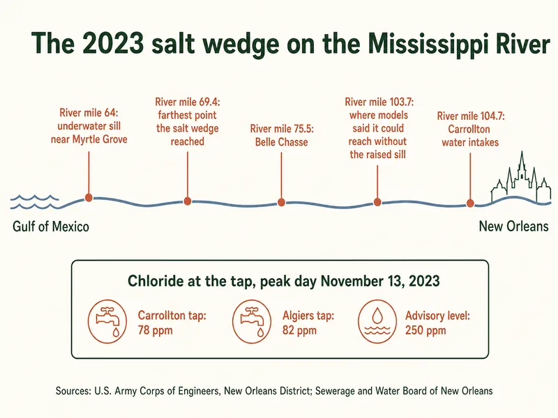
- SWBNO's saltwater page recorded a peak of 78 ppm chloride at the Carrollton tap and 82 ppm at the Algiers tap on November 13, 2023, against a 250 ppm advisory level.
- SWBNO says its treatment plants "cannot remove salt from water," and boiling and common home filters cannot either.
- The 2025 Carrollton Water Works report lists 27 mg/L chloride and 22.6 mg/L sodium in East Bank tap water.
What is saltwater intrusion in the Mississippi?
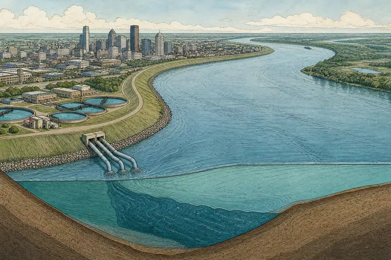
Saltwater intrusion in the Mississippi is the movement of salty Gulf of Mexico water upstream along the bottom of the river, under the fresh water flowing down. Salt water is denser than fresh water, so it slides along the riverbed in a long, tapered layer called the salt wedge. Its leading edge, the toe, is what threatens drinking water intakes upstream.
New Orleans and most of Jefferson Parish draw their tap water from the river. The 2025 report for Carrollton Water Works (East Bank New Orleans) lists its sources as two surface-water intakes on the Mississippi, SWBNO's Algiers plant has its own river intake, and the West Jefferson plant's 2025 report lists surface-water intakes. That is why a wedge creeping upriver during a drought becomes a tap water question.
Why does the salt wedge move upriver?
The salt wedge moves upriver when the river's flow is too weak to push it back toward the Gulf. The Corps' New Orleans District says intrusion occurs when Mississippi River flow falls below 300,000 cubic feet per second. Flow drops in dry years, when less water comes down from upstream.
Once it starts moving, the dense salt water can travel a long way along the bottom before anything stops it. That is the reason for the Corps' answer: a sill, or underwater ridge of sediment, built across the riverbed to block the wedge's path. Ships still need to pass over it, which shapes how it is built.
The 2023 salt wedge in numbers
- 300,000 cfsRiver flow below which saltwater intrusion occursUSACE New Orleans District, via DVIDS
- 69.4River mile where the 2023 wedge's toe stopped, below Belle Chasse (mile 75.5)USACE New Orleans District, via DVIDS
- 78 ppmPeak chloride at the Carrollton tap, November 13, 2023 (advisory level 250 ppm)Sewerage and Water Board of New Orleans
- 27 mg/LChloride in East Bank New Orleans tap water, 2025 reportLDH, Carrollton Water Works 2025 report
What happened in 2023?
In 2023 low river flow let the wedge move upriver again, a year after the Corps had built a sill in 2022. The Corps began building a sill on July 11, 2023, at about river mile 64 near Myrtle Grove, first to a depth of 55 feet below the surface. Sills had also been built in 1988, 1999, 2012 and 2022.
When the wedge kept coming, the Corps raised the sill to 30 feet below the surface, leaving a 620-foot notch at 55 feet for ships. That work started on September 26 and was completed on October 12, 2023. The toe stopped at river mile 69.4, below Belle Chasse at mile 75.5. Corps models showed that without the raise it could have reached mile 103.7, about one mile short of the Carrollton intakes at mile 104.7.
SWBNO planned for the worst case. Its saltwater page described working with the Corps to barge about 14 million gallons of fresh water a day to the Algiers plant, to blend with river water if needed. SWBNO's page, last updated in January 2025, says salt water "has not reached Orleans Parish."
How does the underwater sill slow saltwater intrusion?
The sill works as a dam for the bottom layer of the river only. Fresh water flows over the top toward the Gulf, while the dense salt water moving upstream along the bed runs into the ridge and is held back. A taller sill blocks more of the wedge, which is why the Corps raised the 2023 sill from 55 feet down to 30 feet down.
The notch is the compromise. The Corps left a 620-foot-wide gap at the original 55-foot depth in the raised sill, keeping a channel open for shipping while the rest of the ridge stood 25 feet higher. The Corps' New Orleans District team received an innovation award in 2024 for this notched design.
| Measure | Figure | What it means | Source |
|---|---|---|---|
| Normal river chloride | About 20–60 ppm | The usual range at the intakes | SWBNO saltwater page |
| Peak Carrollton tap, Nov 13, 2023 | 78 ppm | Above normal, far below the advisory level | SWBNO saltwater page |
| Peak Algiers tap, Nov 13, 2023 | 82 ppm | Highest tap reading on SWBNO's page | SWBNO saltwater page |
| Advisory level | 250 ppm | Above this, salt can make tap water unsuitable for drinking and cooking | SWBNO saltwater page |
| East Bank tap chloride, 2025 report | 27 mg/L | A normal year, for comparison | LDH 2025 Carrollton report |
What does salt do to tap water and pipes?
At high levels, salt changes the taste of water and raises its sodium, which matters for people on low-sodium diets, people with kidney disease or high blood pressure, dialysis patients, infants and pregnant women, according to SWBNO's saltwater page. SWBNO says its plants' filtration cannot remove salt, and that boiling or common pitcher filters cannot either. In a normal year the levels are low: the 2025 Carrollton report lists 22.6 mg/L sodium and 27 mg/L chloride.
Pipes are the slower concern. SWBNO warns that higher salinity could weaken corrosion control, letting iron and lead from older pipes dissolve into treated water, and that over time high salt levels can damage metal pipes, appliances and water heaters. That is why the lead in drinking water guide and the lead figures in the New Orleans tap water guide matter most in a salty year. In 2023 the tap readings never came near the 250 ppm level.
Which water plants are most at risk from saltwater?
The plants farthest downriver are at risk first, because the wedge reaches them before it reaches New Orleans. In 2023 the toe stopped at river mile 69.4, below Belle Chasse at mile 75.5, so communities downriver of Belle Chasse in Plaquemines Parish sit closer to the wedge than anyone in Orleans or Jefferson Parish. SWBNO's tap data from November 2023 shows Algiers, across the river, slightly saltier than Carrollton at the peak.
Upriver plants, including Carrollton at river mile 104.7, sit well clear in most years. This page does not repeat reports of emergency treatment units or barging in Plaquemines Parish, because those details could not be confirmed in an official source. For a different kind of tap water alert, see the boil water advisory guide; for what is normally in the water, see the New Orleans water hardness guide.
How we put this page together
This page is based on three U.S. Army Corps of Engineers, New Orleans District releases published on DVIDS (July 2023, October 2023 and the 2024 innovation award story), the Sewerage and Water Board of New Orleans saltwater wedge page (last modified January 6, 2025) and LDH's posting of the East Bank plant's 2025 water quality report. Reviewed in October 2026. Raw river readings are not presented as tap water figures. Left out: Plaquemines Parish treatment and barging details, and any forecast for future years, since none could be confirmed.
Common questions
Did salt water reach New Orleans tap water in 2023?
No. SWBNO's page says salt water "has not reached Orleans Parish," and the Corps says the wedge stopped at river mile 69.4, more than 35 miles below the Carrollton intakes.
Can a home water filter remove salt?
SWBNO says boiling and common filters such as pitchers cannot remove salt. Its own plants' filtration cannot either.
Is saltwater intrusion a new problem?
No. The Corps built sills against it in 1988, 1999, 2012 and 2022 before the 2023 sill.
What flow level triggers saltwater intrusion?
The Corps' New Orleans District says intrusion occurs when river flow falls below 300,000 cubic feet per second.
Should people on low-sodium diets worry in a normal year?
The 2025 Carrollton report lists 22.6 mg/L sodium, a normal-year figure. SWBNO's saltwater advice for sensitive groups applies when salt levels rise, so ask a doctor about any personal sodium limit.
Does salt in the river affect water heaters?
SWBNO says that over time high salt levels can damage water heaters and other appliances. 2023 tap levels stayed far below the 250 ppm advisory level.
Where can residents follow saltwater updates?
SWBNO's saltwater wedge page posts the utility's status and readings, and the Corps' New Orleans District announces sill work.
Keep reading
More guides: the slab house plumbing guide home page.